
Atomic Adventure Race (28-Hour)
Trailblazers AR – Charlotte – 3-person Coed
Corbitt Simmons, Matthew Getz, & Libby Fly
May 14th – 15th, 2011
Brutal.
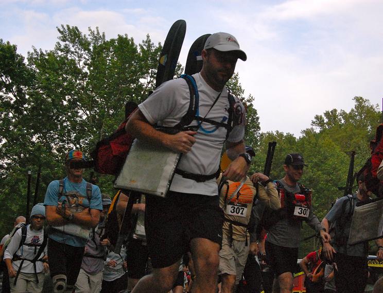
Considered one of the more challenging races in the east, the 2011 Atomic Adventure Race was held in the Chattahoochee National Forest north of Dawsonville and Dahlonega, GA. Originally designed as a 24-hour race, a few weeks before the event, we were notified the length was extended to 28-hours. We would need every minute. The race was separated into nine segments: 4 foot sections, 4 bike sections, and a “paddle” section, with a total of 33 checkpoints. The race was unsupported, and excluding a one-gallon food bag which race support would drop at an undisclosed TA, we were required to carry all gear and remaining food for the entire race. To make it more interesting, we would also be required to carry our paddling gear (paddles, pfds, air pump) throughout nearly the first half of the race.
I teamed with Matt Getz and Libby fly to compete in the three person coed elite division, again under the auspices of Team Trailblazers AR – Charlotte. We checked-in on Friday night and received a set of maps and course directions. After plotting the checkpoints, and even following the pre-race meeting, we couldn’t know exactly what we were in for. The biggest unknown, besides the impending weather, was the paddle section. “Boats” were provided by the race staff, however we weren’t certain of what the boat consisted of until we arrived at the transition area during the race. In addition, the start of the race was a little unclear, but would present itself in due time.
On a side note, I had pulled my back a week before the race, therefore I had remained essentially inactive in order to let it heal as much as possible. I don’t know if it was the nervousness about the race course that lay ahead or my worry about how my back would hold out, but I had a terrible time falling asleep the night before, finally nodding off after midnight. At 4:30am, the alarm blared, and it was all I could do to peel myself out of the bed. By 5am, we were on the road to drop the bikes at a pre-determined drop area which we were told was a one hour out and back drive. It took an hour and a half. With about 30 minutes to spare, we finished our preparations at the race start and lined up at the start line at 7am for the final race briefing. The horn sounded at 7:30am and the teams were off… for a ½ mile jog up to two school buses where we all piled in and were driven to the bike drop. Hmmm. Different. Arriving at the bikes at 9am, we finally were able to actually start the race.
 Frantically, all thirty-five teams piled out of the buses and commenced to donning bike gear and attaching paddling gear to bikes or backpacks. The first leg was an uphill slog for 3 miles gaining 1,000 feet of elevation. Being so soon in the race, there was no time for a warm-up, and much of the field ended up pushing the bikes up the steep incline the last few hundred yards of the hill. On the way up we hit our first bit of rain, but at this point, it felt good and helped keep us cool. After reaching the top, we had a fun, fast, and twisting downhill; slipping and sliding on the gravel, being ever so
  careful not to completely wipe out on the way down. Turning off the road, we pedaled a further 2 miles with 500 feet of elevation gain and soon reached CP1. Here, the field split up, with a majority of the teams staying on the same road and a few of us opting to head back down the 2 miles stretch and catch the paved roads around to CP2/TA1… the transition to the “paddle”.
Now, considering one piece of mandatory team gear was a double-action air pump, it was obvious we would be on some sort of inflatable boat. I had Googled inflatable canoes and was pretty optimistic about what we would encounter, even looking forward to hitting some class I and class II rapids in an inflatable canoe. We would not be so fortunate. We were given a 2-person inflatable pool raft; capacity: 300lbs. We had a 3-person team. Two of us combined were over 300lbs. We made a quick decision, took the raft out of the box and inserted it directly into Matt’s larger pack, forded the river and began our trek of the paddle section! We saw a couple of teams attempting to paddle the kid toys down the river and were completely satisfied with our decision. We bushwhacked up the opposite hillside to a road and completed the next few miles on foot; paddles, pfds, air pump, and boat included. Three miles out, we met the river again and decided to at least take a shot at the paddle. We inflated the boat, stepped into the frigid water and piled into the boat… all three of us squeezed into this toy. It didn’t help the put-in we decided to use was in the middle of a section of rapids. But that’s beside the point.
  The boat was instantly swamped and we attempted paddling our plastic ice bath down the river for 200 yards before deflating, repacking and continuing on foot! More than anything, we were mad we wasted 45 minutes trying this terrible idea out! Even with the river moving at a decent clip, we were able to keep pace on foot. We easily picked up CP3 and CP4 along the way before reaching our first challenge in retrieving CP5. With no direct trails or roads leading close to the checkpoint, we combined a series of bushwhacks and river crossings, and stopping at a camp ground to refill our water before reaching CP5. Although not a tremendously long bushwhack, the route was congested with downed timber, thorn bushes, thick rhododendron, and backwoods poison ivy gardens. After an hour and a half, we finally made it to CP5. The final leg of the “paddle” was a little easier, aided by open fields, another river crossing, and an overgrown trail leading to CP6. Twelve miles of “paddling” and we already felt beaten down!
 The next section was an actual trekking section. Except for one checkpoint (CP9), each of these were seemingly straight forward and simply a matter of pushing ahead. CP7 was a short trek up the road from CP6, and CP8 was less than a mile and a half up a forest service road at an intersection and creek crossing. Originally passing by the location, we turned around and returned to the intersection to began an unlucky search. A new portion of the road was extended beyond what the map showed, therefore there was a little confusion. I still believed it should be there but we just couldn’t locate it. We would find out after the race we turned around not even 50 yards from the checkpoint! At the top of the road, we came across a few teams looking for the checkpoint. Minutes later, one of the race directors drove up and told us the checkpoint should be here and looked confused himself. Not wanting to waste anymore time, we took off up the mountain to the next checkpoint. (This last piece of information was incorrect, the checkpoint was back at the intersection, grrr). CP10 was located atop a hill 3 miles away and 1700 feet up; the last segment a 350’ elevation gain in 0.2 miles through another hillside of poison ivy completely covering the ground, some plants 3’ high and others crawling up surrounding trees. Catching a trail at the top of the mountain, we wound back down to a highway which took us to CP11/TA2 where we would drop the annoying paddle equipment (yes we were still carrying it) and transition to bikes. After nearly 20 miles on foot, we were well past being ready to hop on the bikes.
 At the TA, we had access to a creek where we refilled our water bladders and bottles (popping in iodine pills and covering the taste with nuun electrolyte tablets). We donned our bike gear, attached our lights and took off for a relatively short bike to get to the next TA. The sun had begun setting and we knew we would have to deal with a little cooler weather soon. During the day, the clouds had parted and I figured we were in luck with the rain. Part of this bike section was a retracing of a portion of the course we covered on foot earlier in the day; therefore we knew exactly where our turns were which helped our time on the leg. We were able to catch up and pass a few teams along the way and arrived at TA3 around 10:30pm, just before the recommended time of 11pm. Of course it didn’t hurt that a majority of the route was downhill, giving us a little time to let our legs regain some strength which we would need in the next section.
 The TA3 area was a nice set-up with a fire, our one-gallon food bag, a few cups of fresh water, the Reality Bikes camper, and an area to sit down and plot our next checkpoints for an orienteering section. There were 6 checkpoints (T1-T6) in the section, none of which were accessible by a road, trail, or any other straightforward method. We were required to enter and exit the area through a designated footbridge due to the sensitive streams and fish hatchery in the area. We picked up T1 at the footbridge, then began a 1.2 mile bushwhack to reach T2. The vegetation was thick, rain began to fall, the wind picked up and the temperature began to drop. On our way up to the ridge line we needed to follow, the other Trailblazers AR – Charlotte team (3-person male) came up behind us and joined us for the section. We made our way to the top of the ridge then followed up and down, further west until reaching the CP. The hard climbs up the hills generated enough sweat to drench the inside of my rain jacket as much as the rain was coving the outside. Not a good combination in lower temperatures! Here we found what could loosely be described as a trail, taking us over to the Benton MacKay Trail, an actual marked trail. This was a great relief. Skipping CP3, we continued further down the trail and picked up CP4 where we ran into 3 or 4 other teams. Waist high grass covered in precipitation completely soaked my pants, shoes and socks, so after only halfway through the section I was drenched to the bone. Trekking a road northeast from the area, we reached an intersection and a decision point. To the right, CP5 half a mile away. To the left, CP6 and the way back to the TA. We decided CP5 would be easy enough and went for it. An hour later we returned to the same location (without CP5 as we couldn’t find it), and some of the team was beginning to feel the affects of the adverse weather. A couple of emergency blankets were broken out and the situation was a little touch and go. Luckily, I was feeling alright, albeit a little cold, but we knew we needed to make our way out as soon as possible. Unfortunately, we had a downhill
  trek for over a mile, which didn’t help stoke the body heat. However, the two teams kept moving forward and eventually came across CP6. A little over a mile left to the TA… 100% bushwhack. We would have to navigate back using terrain features, at first through relatively open forest, but finishing with thick underbrush as we got closer to the creek system. We made it back to the TA at 5:30am. Completely frozen at the TA, Matt stoked the fire, I squeezed water our of my clothing, put on a long-sleeve shirt, put on a fresh pair of socks (only to put on wet bike shoes), refueled, filled the water bladders and got ready for the final portion of the race.
I was still a little (okay, a lot) frigid leaving the TA, however the sun would be poking its head soon and the hills leaving the TA helped warm us up quickly. The cut-off time for the race was 1pm, therefore at 6am leaving the TA, we would have to push it to get back in time. Skipping CP17, we caught up with the other Trailblazers (they left just before us at the TA) at CP18. Our next route continued on the same road down a ridgeline to a point at which the gradient was partially conducive to a bikewhack 450’ south down the slope to an old logging road. About a mile and a half down the logging road, we met some congestion, a group of 5 or 6 teams trying to figure out the next move. A few of the teams took off back down the logging road to try to catch a side trail; however we decided to cross the creek next to the trail as we determined this was the waypoint given to us by race staff. The other half of the group of teams joined us and we were all across the creek and off down the trail. A mile or so down the trail it became clear we weren’t on the intended trail of travel. I’ll have to admit that I wasn’t paying close attention to the map since the waypoint, and for the life of me I couldn’t discern exactly where we were. Neither could the other 5 or so teams with us. About this time we were beginning to waste precious time and the worry was whether or not we’ll make it back to the finish before dark, much less the cut-off time of 1pm! We decided we needed to push forward and took off down a bearing where we knew we would hit something if we followed long enough. Only there was no trail. And the slope got steeper. We continued slipping and sliding with our bikes along the side of a mountain becoming more frustrated as we went. At one point, one of the teams was close to pulling out the emergency cell phone! After an hour of fumbling through the woods, we came upon another old logging road and decided it had to lead somewhere. Too gnarly to ride, we pushed our bikes for a little over a mile up and around until we were able to locate ourselves. Soon we found the forest service road that led us out of the wilderness, so the group hopped on the bikes and pushed it as hard as we could. Finding CP19 a little further down the road, we were finally 100% certain we were back on track! After the race, we would realize after the creek crossing, we should’ve taken a left and that trail would take us a short distance to the road out!
Three more checkpoints to go, all on the way back to the finish, and only a little over 8 miles left. However there were two brutal climbs on the way. From CP19, we climbed 950’ in less than two miles. Not being the most talented biker, I was still determined to keep the legs pumping and not stop until we reached CP20. Low and behold, one pedal at a time, I was proud of myself to make it without having to push the bike uphill as others were hoping off! Small feat for some, but for me I was thrilled! The time was 11:45am and we still had one more climb, a long downhill, and a climb up 600 stairs to the top of Amicalola Falls… in just over an hour. The race staff manning CP20 told us if we made the climb on the bike without stopping, we could make it in 25 minutes. We made it in 20! Legs pumping, hill #2 down! We wrote down the time at CP21 and began our last bike leg, a little over 4 miles, and 99% downhill. This was a thrilling ride as we whip ped around gravelly roads, careful not to get to aggressive and fly clear off the side of the mountain. With a little over a mile left, we hit pavement and the speed picked up, reaching nearly 40mph at one point. Halfway down the pavement, I began smelling the brakes, leading me to wonder, “what am I going to do if my brakes give out?” With this in mind, I began paying close attention to the shoulder of the road and developing “Plan B”, in other words my bail-out plan. There wasn’t much shoulder to work with, maybe 2 feet followed by a steel barrier. I couldn’t have been happier when the road began to flatten and the parking lot where we were to drop our bikes was in sight! Quickly checking in at CP22, we leapt off the bikes, stripped off a few items and began our trek to the base of the falls. Then my heart sank. I have a tendency to rub my ring finger with my thumb, a habit I’ve developed since September! Rewinding a bit… shortly after the race start I realized I forgot to take my w
 edding ring off. Back to the present. My ring was gone! Holy crap. It was 12:30. We had a half mile to the base of the falls, a few ramps, then 600 stairs to finish. All in 30 minutes. Crap. I ran back to the bikes knowing that it must’ve come off when I removed my bike gloves. Beginning my search, Peter Jolles from Team Checkpoint Zero and a couple others were standing around and asked me what was up. After telling them, they said go ahead, they’ll look. Almost to the ramps, one of the guys rode up and presented my ring! THANK YOU!! Okay, 12:35, up we started. The first set of stairs, 175 of them. Done, time: 12:39. Okay, this isn’t taking quite as long as I thought. Next set of stairs, 425 of them. One step at a time, we inched our way closer to the finish line. Last step out of the way and there was the finish line… 12:46 and we were done!
Brutal. The only word that comes to mind, and one I heard from many others at the after-race pow-wow. This race really tested our limits, but never broke us. 28 hours. 59 miles on bike, 30 on foot, 200 yards in the ice bath. 20,000 feet of elevation gain. 35 teams began the race, 14 finished officially. Unfortunately a bad decision by us and a few other teams, pushing hard to make it to the finish in time, in not punching CP21 cost us an official finish. Unofficially, we would've rolled in at 6th place in our division and 7th overall, but official is all that counts! Heartbroken, we can still be proud of our finish! Hard tough race, well worth the travel and time. A few strategic mistakes certainly took their toll where we lost a tremendous amount of time. However, I always learn something new in every tough race. Thanks to Team ROC Gear & 4lph4 1337 Adventures for creating an excellent race and especially to all the great sponsors for their help! This race had the best swag I’ve seen at a race! Special thanks to Hi-Tec for a brand new pair of V-Lite Infinity HPi trail shoes! Finally, congrats to my teammates for a great finish, I had a good time pushing through a demanding race!
Trailblazers AR – Charlotte – 3-person Coed
Corbitt Simmons, Matthew Getz, & Libby Fly
May 14th – 15th, 2011
Brutal.
Considered one of the more challenging races in the east, the 2011 Atomic Adventure Race was held in the Chattahoochee National Forest north of Dawsonville and Dahlonega, GA. Originally designed as a 24-hour race, a few weeks before the event, we were notified the length was extended to 28-hours. We would need every minute. The race was separated into nine segments: 4 foot sections, 4 bike sections, and a “paddle” section, with a total of 33 checkpoints. The race was unsupported, and excluding a one-gallon food bag which race support would drop at an undisclosed TA, we were required to carry all gear and remaining food for the entire race. To make it more interesting, we would also be required to carry our paddling gear (paddles, pfds, air pump) throughout nearly the first half of the race.
I teamed with Matt Getz and Libby fly to
 compete in the three person coed elite division, again under the auspices of Team Trailblazers AR – Charlotte. We checked-in on Friday night and received a set of maps and course directions. After plotting the checkpoints, and even following the pre-race meeting, we couldn’t know exactly what we were in for. The biggest unknown, besides the impending weather, was the paddle section. “Boats” were provided by the race staff, however we weren’t certain of what the boat consisted of until we arrived at the transition area during the race. In addition, the start of the race was a little unclear, but would present itself in due time.
On a side note, I had pulled my back a week before the race, therefore I had remained essentially inactive in order to let it heal as much as possible. I don’t know if it was the nervousness about the race course that lay ahead or my worry about how my back would hold out, but I had a terrible time falling asleep the night before, finally nodding off after midnight. At 4:30am, the alarm blared, and it was all I could do to peel myself out of the bed. By 5am, we were on the road to drop the bikes at a pre-determined drop area which we were told was a one hour out and back drive. It took an hour and a half. With about 30 minutes to spare, we finished our preparations at the race start and lined up at the start line at 7am for the final race briefing. The horn sounded at 7:30am and the teams were off… for a ½ mile jog up to two school buses where we all piled in and were driven to the bike drop. Hmmm. Different. Arriving at the bikes at 9am, we finally were able to actually start the race.
 Frantically, all thirty-five teams piled out of the buses and commenced to donning bike gear and attaching paddling gear to bikes or backpacks. The first leg was an uphill slog for 3 miles gaining 1,000 feet of elevation. Being so soon in the race, there was no time for a warm-up, and much of the field ended up pushing the bikes up the steep incline the last few hundred yards of the hill. On the way up we hit our first bit of rain, but at this point, it felt good and helped keep us cool. After reaching the top, we had a fun, fast, and twisting downhill; slipping and sliding on the gravel, being ever so
  careful not to completely wipe out on the way down. Turning off the road, we pedaled a further 2 miles with 500 feet of elevation gain and soon reached CP1. Here, the field split up, with a majority of the teams staying on the same road and a few of us opting to head back down the 2 miles stretch and catch the paved roads around to CP2/TA1… the transition to the “paddle”.
Now, considering one piece of mandatory team gear was a double-action air pump, it was obvious we would be on some sort of inflatable boat. I had Googled inflatable canoes and was
 pretty optimistic about what we would encounter, even looking forward to hitting some class I and class II rapids in an inflatable canoe. We would not be so fortunate. We were given a 2-person inflatable pool raft; capacity: 300lbs. We had a 3-person team. Two of us combined were over 300lbs. We made a quick decision, took the raft out of the box and inserted it directly into Matt’s larger pack, forded the river and began our trek of the paddle section! We saw a couple of teams attempting to paddle the kid toys down the river and were completely satisfied with our decision. We bushwhacked up the opposite hillside to a road and completed the next few miles on foot; paddles, pfds, air pump, and boat included. Three miles out, we met the river again and decided to at least take a shot at the paddle. We inflated the boat, stepped into the frigid water and piled into the boat… all three of us squeezed into this toy. It didn’t help the put-in we decided to use was in the middle of a section of rapids. But that’s beside the point.
  The boat was instantly swamped and we attempted paddling our plastic ice bath down the river for 200 yards before deflating, repacking and continuing on foot! More than anything, we were mad we wasted 45 minutes trying this terrible idea out! Even with the river moving at a decent clip, we were able to keep pace on foot. We easily picked up CP3 and CP4 along the way before reaching our first challenge in retrieving CP5. With no direct trails or roads leading close to the checkpoint, we combined a series of bushwhacks and river crossings, and stopping at a camp ground to refill our water before reaching CP5. Although not a tremendously long bushwhack, the route was congested with downed timber, thorn bushes, thick rhododendron, and backwoods poison ivy gardens. After an hour and a half, we finally made it to CP5. The final leg of the “paddle” was a little easier, aided by open fields, another river crossing, and an overgrown trail leading to CP6. Twelve miles of “paddling” and we already felt beaten down!
 The next section was an actual trekking section. Except for one checkpoint (CP9), each of these were seemingly straight forward and simply a matter of pushing ahead. CP7 was a short trek up the road from CP6, and CP8 was less than a mile and a half up a forest service road at an intersection and creek crossing. Originally passing by the location, we turned around and returned to the intersection to began an unlucky search. A new portion of the road was extended beyond what the map showed, therefore there was a little confusion. I still believed it should be there but we just couldn’t locate it. We would find out after the race we turned around not even 50 yards from the checkpoint! At the top of the road, we came across a few teams looking for the checkpoint. Minutes later, one of the race directors drove up and told us the checkpoint should be here and looked confused himself. Not wanting to waste anymore time, we took off up the mountain to the next checkpoint. (This last piece of information was incorrect, the checkpoint was back at the intersection, grrr). CP10 was located atop a hill 3 miles away and 1700 feet up; the last segment a 350’ elevation gain in 0.2 miles through another hillside of poison ivy completely covering the ground, some plants 3’ high and others crawling up surrounding trees. Catching a trail at the top of the mountain, we wound back down to a highway which took us to CP11/TA2 where we would drop the annoying paddle equipment (yes we were still carrying it) and transition to bikes. After nearly 20 miles on foot, we were well past being ready to hop on the bikes.
 At the TA, we had access to a creek where we refilled our water bladders and bottles (popping in iodine pills and covering the taste with nuun electrolyte tablets). We donned our bike gear, attached our lights and took off for a relatively short bike to get to the next TA. The sun had begun setting and we knew we would have to deal with a little cooler weather soon. During the day, the clouds had parted and I figured we were in luck with the rain. Part of this bike section was a retracing of a portion of the course we covered on foot earlier in the day; therefore we knew exactly where our turns were which helped our time on the leg. We were able to catch up and pass a few teams along the way and arrived at TA3 around 10:30pm, just before the recommended time of 11pm. Of course it didn’t hurt that a majority of the route was downhill, giving us a little time to let our legs regain some strength which we would need in the next section.
 The TA3 area was a nice set-up with a fire, our one-gallon food bag, a few cups of fresh water, the Reality Bikes camper, and an area to sit down and plot our next checkpoints for an orienteering section. There were 6 checkpoints (T1-T6) in the section, none of which were accessible by a road, trail, or any other straightforward method. We were required to enter and exit the area through a designated footbridge due to the sensitive streams and fish hatchery in the area. We picked up T1 at the footbridge, then began a 1.2 mile bushwhack to reach T2. The vegetation was thick, rain began to fall, the wind picked up and the temperature began to drop. On our way up to the ridge line we needed to follow, the other Trailblazers AR – Charlotte team (3-person male) came up behind us and joined us for the section. We made our way to the top of the ridge then followed up and down, further west until reaching the CP. The hard climbs up the hills generated enough sweat to drench the inside of my rain jacket as much as the rain was coving the outside. Not a good combination in lower temperatures! Here we found what could loosely be described as a trail, taking us over to the Benton MacKay Trail, an actual marked trail. This was a great relief. Skipping CP3, we continued further down the trail and picked up CP4 where we ran into 3 or 4 other teams. Waist high grass covered in precipitation completely soaked my pants, shoes and socks, so after only halfway through the section I was drenched to the bone. Trekking a road northeast from the area, we reached an intersection and a decision point. To the right, CP5 half a mile away. To the left, CP6 and the way back to the TA. We decided CP5 would be easy enough and went for it. An hour later we returned to the same location (without CP5 as we couldn’t find it), and some of the team was beginning to feel the affects of the adverse weather. A couple of emergency blankets were broken out and the situation was a little touch and go. Luckily, I was feeling alright, albeit a little cold, but we knew we needed to make our way out as soon as possible. Unfortunately, we had a downhill
  trek for over a mile, which didn’t help stoke the body heat. However, the two teams kept moving forward and eventually came across CP6. A little over a mile left to the TA… 100% bushwhack. We would have to navigate back using terrain features, at first through relatively open forest, but finishing with thick underbrush as we got closer to the creek system. We made it back to the TA at 5:30am. Completely frozen at the TA, Matt stoked the fire, I squeezed water our of my clothing, put on a long-sleeve shirt, put on a fresh pair of socks (only to put on wet bike shoes), refueled, filled the water bladders and got ready for the final portion of the race.
I was still a little (okay, a lot) frigid leaving the TA, however the sun would be poking its head soon and the hills leaving the TA helped warm us up quickly. The cut-off time for the race was 1pm, therefore at 6am leaving the TA, we would have to push it to get back in time. Skipping CP17, we caught up with the other Trailblazers (they left just before us at the TA) at CP18. Our next route continued on the same road down a ridgeline to a point at which the gradient was partially conducive to a bikewhack 450’ south down the slope to an old logging road. About a mile and a half down the logging road, we met some congestion, a group of 5 or 6 teams trying to figure out the next move. A few of the teams took off back down the logging road to try to catch a side trail; however we decided to cross the creek next to the trail as we determined this was the waypoint given to us by race staff. The other half of the group of teams joined us and we were all across the creek and off down the trail. A mile or so down the trail it became clear we weren’t on the intended trail of travel. I’ll have to admit that I wasn’t paying close attention to the map since the waypoint, and for the life of me I couldn’t discern exactly where we were. Neither could the other 5 or so teams with us. About this time we were beginning to waste precious time and the worry was whether or not we’ll make it back to the finish before dark, much less the cut-off time of 1pm! We decided we needed to push forward and took off down a bearing where we knew we would hit something if we followed long enough. Only there was no trail. And the slope got steeper. We continued slipping and sliding with our bikes along the side of a mountain becoming more frustrated as we went. At one point, one of the teams was close to pulling out the emergency cell phone! After an hour of fumbling through the woods, we came upon another old logging road and decided it had to lead somewhere. Too gnarly to ride, we pushed our bikes for a little over a mile up and around until we were able to locate ourselves. Soon we found the forest service road that led us out of the wilderness, so the group hopped on the bikes and pushed it as hard as we could. Finding CP19 a little further down the road, we were finally 100% certain we were back on track! After the race, we would realize after the creek crossing, we should’ve taken a left and that trail would take us a short distance to the road out!
Three more checkpoints to go, all on the way back to the finish, and only a little over 8 miles left. However there were two brutal climbs on the way. From CP19, we climbed 950’ in less than two miles. Not being the most talented biker, I was still determined to keep the legs pumping and not stop until we reached CP20. Low and behold, one pedal at a time, I was proud of myself to make it without having to push the bike uphill as others were hoping off! Small feat for some, but for me I was thrilled! The time was 11:45am and we still had one more climb, a long downhill, and a climb up 600 stairs to the top of Amicalola Falls… in just over an hour. The race staff manning CP20 told us if we made the climb on the bike without stopping, we could make it in 25 minutes. We made it in 20! Legs pumping, hill #2 down! We wrote down the time at CP21 and began our last bike leg, a little over 4 miles, and 99% downhill. This was a thrilling ride as we whip
 ped around gravelly roads, careful not to get to aggressive and fly clear off the side of the mountain. With a little over a mile left, we hit pavement and the speed picked up, reaching nearly 40mph at one point. Halfway down the pavement, I began smelling the brakes, leading me to wonder, “what am I going to do if my brakes give out?” With this in mind, I began paying close attention to the shoulder of the road and developing “Plan B”, in other words my bail-out plan. There wasn’t much shoulder to work with, maybe 2 feet followed by a steel barrier. I couldn’t have been happier when the road began to flatten and the parking lot where we were to drop our bikes was in sight! Quickly checking in at CP22, we leapt off the bikes, stripped off a few items and began our trek to the base of the falls. Then my heart sank. I have a tendency to rub my ring finger with my thumb, a habit I’ve developed since September! Rewinding a bit… shortly after the race start I realized I forgot to take my w
 edding ring off. Back to the present. My ring was gone! Holy crap. It was 12:30. We had a half mile to the base of the falls, a few ramps, then 600 stairs to finish. All in 30 minutes. Crap. I ran back to the bikes knowing that it must’ve come off when I removed my bike gloves. Beginning my search, Peter Jolles from Team Checkpoint Zero and a couple others were standing around and asked me what was up. After telling them, they said go ahead, they’ll look. Almost to the ramps, one of the guys rode up and presented my ring! THANK YOU!! Okay, 12:35, up we started. The first set of stairs, 175 of them. Done, time: 12:39. Okay, this isn’t taking quite as long as I thought. Next set of stairs, 425 of them. One step at a time, we inched our way closer to the finish line. Last step out of the way and there was the finish line… 12:46 and we were done!
Brutal. The only word that comes to mind, and one I heard from many others at the after-race pow-wow. This race really tested our limits, but never broke us. 28 hours. 59 miles on bike, 30 on foot, 200 yards in the ice bath. 20,000 feet of elevation gain. 35 teams began the race, 14 finished officially. Unfortunately a bad decision by us and a few other teams, pushing hard to make it to the finish in time, in not punching CP21 cost us an official finish. Unofficially, we would've rolled in at 6th place in our division and 7th overall, but official is all that counts! Heartbroken, we can still be proud of our finish! Hard tough race, well worth the travel and time. A few strategic mistakes certainly took their toll where we lost a tremendous amount of time. However, I always learn something new in every tough race. Thanks to Team ROC Gear & 4lph4 1337 Adventures for creating an excellent race and especially to all the great sponsors for their help! This race had the best swag I’ve seen at a race! Special thanks to Hi-Tec for a brand new pair of V-Lite Infinity HPi trail shoes! Finally, congrats to my teammates for a great finish, I had a good time pushing through a demanding race!

No comments:
Post a Comment